

Item number: TOW449 Genuine Antique Printed Color Map
1892
Maker: Home Library & Supply Association.
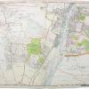
Antique printed color map of the city of New Orleans, Louisiana (Recto) showing a general overview of city blocks, names of major streets, railroads, and some points of interest (e.g. parks, cemeteries, University of Louisiana, etc.) including a reference to points of interest. Verso: Map of Cincinnati, Ohio showing a general overview of city blocks, names of major streets, railroads, bridges, and points of interest (e.g. parks, cemeteries, etc.) including a reference to points of interest. Published in “The Pacific Coast and the World” by the Home Library and Supply Association, 1892. Very good overall antique condition with some mild toning/foxing (mainly at the outer edges.) Recto map (New Orleans) measures approximately 11.25″ x 9.25″ (H x W) to the neatline. Verso map (Cincinnati) measures approx. 9.25″ x 12″ to the neatline.
Item Number: TOW449
Be the first to review “1892 – New Orleans, Verso: Map of Cincinnati – Antique Map Cheap Get To Buy”
Related products

Reference

Atlases & Maps

Reference

Reviews
There are no reviews yet.