
Item number: RHO120Genuine Antique Hand Colored Map
1870
Maker: Beers.
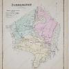
Antique map of Coventry and West Greenwich, RI, from the Atlas of the State of Rhode Island and Providence Plantations, Beers, 1870. With inset maps of Noose Neck (part of West Greenwich) and Washington (part of Coventry). Good condition, with toning, small tears at paper edges, and a water stain at bottom that can be hidden by a mat when framing. Measures approx. 14.5 x 24 inches.
Item Number: RHO120
Be the first to review “1870 – Coventry and West Greenwich – Antique Map Discount Reliable”
Related products
Sale

Atlases & Maps
Original price was: $7.87.$5.90Current price is: $5.90.
Sale

Reference
Original price was: $130.00.$99.00Current price is: $99.00.
Sale

English as a Second Language
Original price was: $6.99.$5.31Current price is: $5.31.
Sale

Original price was: $14.00.$11.06Current price is: $11.06.
Reviews
There are no reviews yet.