

Item number: MAI113Genuine Antique Hand Colored Engraved Map
c. 1842
Maker: Tanner.
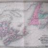
From the “Universal Atlas” of master cartographer Henry Schenck Tanner, hand colored engraved antique map of Maine, with very fine detail of the state’s famous rocky shores and islands, rivers, canals and railroads, as well as legends of current and historical population figures; also shows beyond the then current (1842) northwest boundary of the state, the “boundary according to the Treaty of 1783”, referring to the Treaty of Paris that ended the American Revolution. Very good overall antique condition, approx. 14 x 11.5 inches. **SOLD**
Item Number: MAI113
Be the first to review “1842 – A New Map of Maine *****SOLD***** – Antique Map Free Shipping Browse”
Related products
Sale

Reference
Original price was: $3.00.$2.22Current price is: $2.22.
Sale

Original price was: $41.00.$30.34Current price is: $30.34.
Sale

Original price was: $10.00.$8.00Current price is: $8.00.
Sale

Atlases & Maps
Original price was: $19.14.$14.93Current price is: $14.93.
Reviews
There are no reviews yet.